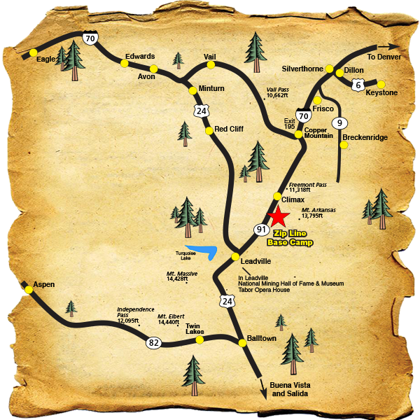
DIRECTIONS TO TOP OF THE ROCKIES ZIP LINE BASE CAMP
For Navigation purposes use this address:
6492 Highway 91, Leadville, Colorado 80461. We are not in the town of Leadville, we are approximately 14 MILES SOUTH OF COPPER MOUNTAIN AND 7 MILES NORTH OF LEADVILLE.
FROM INTERSTATE 70, TAKE EXIT 195 (COPPER MOUNTAIN/LEADVILLE EXIT). CONTINUE SOUTH ON COLORADO HIGHWAY 91 APPROXIMATELY 14 MILES. LOOK FOR MILE MARKER 7 ON THE LEFT, SLOW DOWN AND PREPARE TO MAKE A CAUTIOUS LEFT HAND TURN INTO OUR DRIVEWAY. YOU WILL SEE OUR BLUE NAME SIGNS ON THE RIGHT AND A RED SIGN ON THE LEFT, “WHOA SLOW DOWN, ZIP LINING AHEAD”. IF YOU PASS MILE MARKER 6, YOU HAVE GONE TOO FAR.
From the South, travel North through Leadville on Highway 91. Look for Mile Marker 6 on the right, the blue Name Signs (Top of the Rockies Zip Line) on the right, and prepare to turn right into our well-marked driveway. If you pass Mile Marker 7, you have gone too far.
6492 Highway 91, Leadville, Colorado 80461